This is a second part in a two part series to lock down some information about intersections, we go a
bit more in depth with traffic signal operations at intersections. This
information builds off of part 1 about some of the basic “surface level”
knowledge of intersections. In part 2, we
attempt to explain more advance signal operations and the future technology that
has the potential to completely revolutionize signalized intersections and
signal operations as we know it today.
Signal Phases
As
mentioned in Part 1, most major intersections in major metropolitan areas, intersection
signals are based on a pre-timed
setting that allows for variation based on loop detector signals from vehicle
arrivals. These pre-timed settings are determined by a traffic engineer
(usually with the help of some software) and recorded on signal timing sheets
for reference. A semi-actuated or fully actuated intersection would have the
following (among a list of other values for signal operation), on signal timing
sheets.
·
Minimum
Green
·
Yellow
·
All
Red
·
Walk
time
·
Cycle
length
·
Lag
Phases
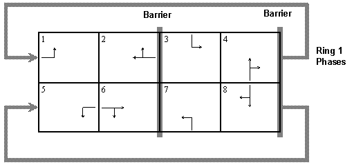
NEMA Phases – Each direction of traffic is assigned a
numbered NEMA phase to organize a signals operation. Through directions are
assigned even numbers in a clock wise direction usually with the major street labelled
2 or 6. Left turn movements are oddly numbered in a clock wise direction, with
1 being assigned across the intersection from the through 2 movement. Below is
a diagram of a street layout with the NEMA phases labelled.
Minimum Green – The minimum allowed green time for a particular
phase. This allows for a minimum clearance for just one vehicle to pass through
an intersection. Usually 5-10 seconds for a medium sized intersection
Yellow – The amount of time given to the yellow phase of
a light.
All Red – Each intersection has a period of time that
has all the signal directions displaying red. After each phase, and a conflicting
movement proceeds, the intersection has a “clearing” period to make sure all
the yellow light runners have passed through the intersection completely.
Walk Time – The time
allocated for pedestrians to cross the street when the pedestrian button is
pressed/activated.
Cycle Length – Sum of all the phases green, yellow and all
red times to complete one cycle of an intersection. There is usually a schedule
for each day of the week and time of day for the cycle length to change
accordingly.
Lag Phases – At the start of a cycle, left turn movements
(phase 1 and 5) can lead, therefore lagging phases 2 and 6. However, 1 and 5
could also be the lag phases depending on how the signal is set up. The Lag
phase information states which phases lag for the cycle.
Signal
timing sheets have a whole slew of other information, above is just a sampling
of some basic ones to get become familiar with this information.
Traffic Light
Synchronization
On streets
with multiple intersections in a row, it helps to have the lights coordinatedin such a way to have vehicles approach all green lights at each intersection.
Trying to have coordination in all directions is very difficult, but for the
larger streets that carry more through traffic, it’s feasible to have these
movements coordinated. This keeps traffic flowing along the major arterial streets
with minimal stopping, breaking and emissions produced. Synchronizing lights,
while costly, is very beneficial to drivers making a trip through a series of
the lights along a street segment.

Synchronized traffic intersections will have an offset value on the signal timing charts for the traffic engineers
to use when programming the traffic signals. This offset value is the number of
seconds it takes for a car traveling from being stopped at one intersection to
the subsequent intersection down the road. This travel time allows the cycle
length of the two intersections to be offset by a specific amount of time to
allow cars to travel between the two intersections without stopping for a red
light. Effectively creating a "green wave" for drivers.
Synchronizing
lights can become messy very quickly depending on the streets being analyzed.
To help, computer software is available to optimize signal timing most efficiently.
Synchro
is one common traffic software that calculates street signals to have the
optimum signal timing values based on the inputted data. Synchro requires the
user to input the existing roadway design, geometry, traffic volumes (number of
cars), among other data, to have it calculate the most efficient signal timing
values, such as cycle length, green times, etc.

Collecting
data for inputting into Synchro
requires vehicle counts to be collected. In it’s current state today, collecting traffic counts is a very time
consuming and manually driven process. Because this is a time consuming and
expensive process, updating traffic signals for synchronization only occurs
once every few years (or more). This creates excess traffic congestion when travel
patterns change on arterial streets. Traffic signal coordination does not have
to be like this however, it can be an automatic, easy to maintain and provide
peak performance to all users. In the next section we look at how this could be
a serious possibility.
Smart Signal Technology
At fully-actuated
intersections, street embedded wire inductive loops provide a sensor technology
to have cars signal their presence in a specific lane. As an example, inductive
loops in the left turn lane would signal to the traffic cabinet the left turn
signal needs to be cycled through. If the loop does not detect a vehicle, it
would skip that phase during the cycle to save time. These inductive loops at
intersections however are wired differently then inductive loops
on highways, in that they are all pulled together for each movement (not
individual lanes) and the computer in the traffic cabinet only detects a
vehicle in binary form (vehicle present or not present). Along the side of the
intersection is a pull
box where all these wires are reduced down to each of their traffic movements
(left turn, through, right turn). Any vehicle counts are not obtained, as these
sensors only function as dummy “on/off” switches.
In the future,
more advanced technology could change this current design of intersections to
allow for “smart” data
collection to occur automatically every second of the
day. By using the loops in the ground to collect vehicle counts, costs
can be
reduced for the required signal optimization data. Vehicle counts and
signal optimization can be done on the fly or every 24 or 48 hours if
necessary. This time consuming and high cost operation today will be
completely automated down the road.
Of course this all assumes we will still be using
human driven cars. With the current advancement from
Google of autonomous cars,
signalized intersections as we know it today wouldn't be necessary as
the
vehicles could navigate through a joining of two perpendicular streets by
calculating each car's trajectory
in advanced. This type of travel would be truly remarkable, of course
we probably not even care because we would looking down at a tablet
doing a
Google search or some other
mind stretching task.
One of the key challenges with modern signal systems is keeping track of how each intersection is configured—phases, detectors, timings, and operational constraints. The General Traffic Signal Specification (GTSS), available at http://gtss.dev, provides a simple, standardized way to describe intersection configurations in a structured, human and machine-readable format. By using GTSS, agencies can streamline how they document and share signal setups, reduce manual errors, and enable automated checks when processing high-resolution controller data. This means that as data is analyzed, software can automatically verify that detectors, phases, and movements are behaving as intended, helping engineers quickly identify issues and focus on the locations that need attention most.

Building on that concept, Traffic Signal Kit provides free, practical tools for processing high-resolution controller data. These tools go beyond traditional Signal Performance Measures by offering new insights into safety-related events, detector health, and real-world operational behavior at intersections. Instead of only looking at standard delay or progression metrics, agencies can uncover patterns such as potential red-light-running risks, split failures, or malfunctioning detection—helping them prioritize improvements using data they already collect.
To conclude, Intersections have come a long way from a
4 way dirt road junction, however with improved technology and acceptance by
cities, intersections can continue to be safer, offer less dwell time and lower emissions. If your looking for more information about traffic signal phasing and traffic cabinets I recommend the
How Traffic Signals Work Blog.


0 comments:
Post a Comment