A Look at Traffic

Case studies to allow an analysis of traffic.

Tuesday, March 6, 2012

All About: Intersections - Part 1 of 2


I believe that in transportation, some of the really interesting things happen when things come together. Literally! Grand Central for example is a crazy happening place simply because of all the transportation modes that feed to one location. In an Auto network we see this occur a lot more frequently at Intersections. Two streets crossing requires a safe and effective means for all vehicles to travel safely in their intended direction. I see the intersection as a market place where people come to share time together before they continue on their journey. For large intersections this requires money (~$200,000+ (2011)), advance planning, engineering, and important technology to keep drivers happy. In this first post of a two part series, I want to layout three aspects of basic traffic elements of an intersection that keep cars, pedestrians and Bicyclists moving.

Pedestrian Crossings/ Bike Buttons

Facilitating the movement of pedestrians is also a key component of a safely operating intersection. Typically pedestrian buttons and signs give walkers, joggers and dog walker’s informative information about the traffic signal and green directions. More commonly today, these facilities are being upgraded to have audio chirps, tactile padding, and large “mushroom” buttons. All of these features are synergized together to make a pleasant walking environment for pedestrians.

In addition to these pedestrian improvements, bicycle buttons have been added on the outward facing pole to give “in-gutter” bikers the ability to request a crossing. One major difference between his button and a pedestrian button is the amount of time allocated for each button to cross the street. A pedestrian button can give 20 to 30 seconds, while a bike button would give the same amount of time as a single vehicle to cross the intersection. This helps the efficiency of the intersection and prevents too much time given to pedestrians who won’t use it.

More recently we have seen bicycle detectors in the bike lane on the ground. Similar to a vehicle inductance loop to detect a car, these bicycle loops are sensitive enough to detect a bike moving over the loop. While these are yet to be perfect, depending on the mass and material of the bike, they have helped bicyclist automatically interact with the intersection, the only issue still seams to be detecting carbon fiber bikes. Solving this could lead to a huge jackpot for entrepreneurs. With bike detection becoming more common, I can only hope we begin to see bike signal coordination to allow bicyclist to have a pleasant green light stroll the same way cars do!
Vehicle Detection
Traditionally, a fixed time is allocated for each traffic direction no matter how many vehicles line up at each approach. The downside of this, is that it can waste time by giving a green light to a direction without any vehicles waiting. To solve this, wires have been put in the ground in the shape of a circular loop to detect vehicles. These are typically placed closest to the crosswalks to capture the first few row of vehicles.
Installation of these wires requires lane closure to make cuts in the pavement, allowing for the wire to be dropped inside, and then a sealant is placed over the cut to securely embed the wire in the ground. All the wires from the different lanes are pulled to the side of the road into what is known as a pull box, and fed into a traffic cabinet on the side of the road. Electric current  is run through the wires and when a large metal object (like a car) hovers over the wire, the change in current is measured and a vehicle is detected.

Cycle Length
Besides some of the physical geometries of an intersection signal, we can also consider the underlying operation of how a light changes between red, yellow and green for the different movements. No matter how the intersection is set up, a signalized intersection typically operates on a cycle length. A cycle length is simply the amount of time given to have a green period for all the different movements of traffic. Typically a cycle length varies from 60 seconds to 2 minutes depending on the size and amount of vehicles using the intersection.
The cycle length is determined by the traffic engineers either manually or via computer programs for optimization purposes. This and all the other relevant information of a traffic signal is stored on signal timing charts with the city. Through a public records request, anyone can request this information and use it for their own purposes (usually Traffic Engineering Consulting firms will request this from cities when performing a project dealing with the city signals). In addition to cycle length these charts provide NEMA phase information, green, yellow and red times, as well as time of day charts to show when a cycle length may change during the day based on historical demand traffic volumes.

I hope this has outlined some of the basic characteristics of an intersection and provided relevant information for your next encounter with one (hopefully on a bike!). In my next segment focused about intersections, I plan to explore information about signal coordination and optimization and give some ideas for future intersection technology.

Continue Reading Part 2 of 2.

Read more...

Wednesday, January 18, 2012

Job Searching: List of Transportation Engineering Companies

I have been meaning to post this list of Transportation Engineering companies up for some time now. I created this list when I was job searching for a transportation engineering related job. I had a few more columns added to keep track of if I applied or not or what contact information I had with the company. While this list is by no means complete, I think it is a good starting point to start applying to some companies. If your looking to make money in the transportation consulting/engineering field, one of these companies is bound to be a good fit for your career! It has a little "bike friendly bias", sorry about that. I can only hope the links still work for you (if not, let me know). The locations are by no means complete, they just scattered information if I happened to look up where their offices are. Good luck in the job search!


CompanyWebsiteOffice Locations
SRF Consulting Grouphttp://www.srfconsulting.com/careers/Openings.aspxMinneapolis, Bismarck, Fargo, Madison, St. Louis
Cambridge Systematicshttp://www.camsys.com/com_career_opportunities.htm#tdf000246Atlanta, Austin, Cambridge, Chicago, Denver, Ft. Lauderdale, New York, Oakland, Tallahassee, Washington
Kittelson and Associates Inc.http://www.kittelson.com/Anchorage, Baltimore, Bend, Boise, Brisbane, Fort Lauderdale, Oakland, Orlando, Phoenix, Portland, Reston, Sacramento, Tucson
The Mobility Grouphttp://www.mobilitygrp.comIrvine, CA
Atkinshttp://www.atkinsglobal.com/Global
STVhttp://www.stvinc.com/Douglassville, New York, Irvine, Los Angeles, Oakland, Rancho Cucamonga, San Jose, Denver, Stratford, Jacksonville, Orlando, Atlanta, Duluth, Chicago, Overland Park, Boston, Baltimore, California, Charlotte, Newark, Trenton, Toronto, Harrisburg, Philadelphia, Pittsburgh, Williamsport, North Charleston, Rock Hill, Dallas, Houston, Fairfax, Norfolk, Richmond, Seattle
SIMCO Engineeringhttp://www.simcopc.com/about.htmNew York, New York
Fehr & Peershttp://www.fehrandpeers.com/career-opportunities/Walnut Creek, Denver, Honolulu, Inland Empire, Oakland, Orange County, Reno, Roseville, San Diego, San Francisco, San Jose, Santa Monica, Seattle, Utah
IBI Grouphttp://www.ibigroup.com/Pages/Home.aspxToronto, Alma, Brantford, Calgary, Edmonton, Fort McMurray, Hamilton, Kingston, Kitchener, London, Mississauga, Montreal, Ottawa, Quebec, Richmond Hill, Seguenay, Vancouver, Waterloo, Alexandria, Bakersfield, Binghamton, Boston, Columbia, Coral Springs, Denver, Houston, Irvine, Knoxville, Las Vegas, Los Angeles, Maitland, New York, Park City, Philadelphia, Pompano Beach, Portland, Raleigh, Salt Lake City, San Diego, San Jose, San Luis Obispo, Sarasota, Seattle, Southfield, Tampa, West Palm Beach, Europe, China, Middle East/India, Africa, Caribbean
URS Corporationhttp://www.urscorp.com/Global
RSGhttp://www.rsginc.com/White River Junction, Burlington, Chicago, Salt Lake City, Concord, Arlington
Stantec http://www.stantec.com/careers.htmlGlobal
HNTBhttp://www.hntb.com/careers/job-searchLos Angeles, Oakland, Riverside, Roseville, San Diego, San Francisco, San Jose, Santa Ana, Denver, Rocky Hill, Bartow, Jacksonville, Lake Mary, Miami, Tallahassee, Tampa, Atlanta, Guam, Chicago, Indianapolis, Overland Park, Louisville, Baton Rouge, Metairie, Westbrook, Boston, Chelmsford, Detroit, East Lansing, Minneapolis, Biloxi, Kansas, St. Louis, Omaha, Camden, Newark, Wayne, Albany, New York, Charlotte, Raleigh, Cincinnati, Cleveland, Columbus, Portland, Harrisburg, Norristown, Philadelphia, Pittsburgh, Austin, Brownsville, Dallas, El Paso, Houston, Plano, San Antonio, Salt Lake City, Arlington, Bellevue, Fairmont, Scott Depot, Madison, Milwaukee
CH2MHillhttp://www.careers.ch2m.com/worldwide/en/jobs-in/#my_careerlevelGlobal
Parsons Brinckerhoffhttp://www.pbworld.com/capabilities_projects/transportation/Global
Lee Engineeringhttp://www.leeengineering.com/Careers.htmlPhoenix, Dallas, Albuquerque, Oklahoma City
Iterishttp://iteris.catsone.com/careers/Santa Ana, San Diego, Long Beach, Los Angeles, Ontario, Santa Ana, Berkeley, Among many others in Canada, Latin America and Asia
Advantec Consulting Engineershttp://www.advantec-usa.com/index.php?option=com_jobline&Itemid=96Diamond Bar, Ontario
Urban Crossroadshttp://www.urbanxroads.com/careers.aspxIrvine, Riverside, Carlsbad
Wiley Engineeringhttp://www.wileyengineering.com/html/careers.htmlHauppauge, New York
Halcrow (a CH2M Hill Company)http://www.halcrow.com/Working-for-us/North-America-careers/New York, Global
Parsonshttp://www.parsons.com/careers/jobs/Pages/default.aspxHuntsville, Anchorage, Tempe, El Segundo, Irvine, Lake Forest, Los Angeles, Manhattan Beach, Ontario, Pasadena, Sacramento, San Diego, San Francisco, San Jose, Walnut Creek, Colorado Springs, Denver, East Berline, Washington D.C., Jacksonville, Miami, Orlando, Tallahassee, Tampa, West Palm Beach, Atlanta, Norcross, Hagatna, Honolulu, Chicago, Des Plaines, Indianapolis, Kansas City, Louisville, Baltimore, Columbia, Billerica, Boston, Southfield, Minneapolis, Chesterfield, Bellevue, Las Vegas, Concord, Lawrenceville, Mays Landing, Somerset, Buffalo, Fort Edward, Jamaica, New York, Syracuse, Charlotte, Raleigh, Cincinnati, Cleveland, Midwest City, Philadelphia, Pittsburgh, Aiken, Brentwood, Memphis, Austin, Fort Worth, Houston, Richardson, San Antonio, South Jordan, Arlington, Centreville, Fairfax, Martinsville, Norfolk, Richmond, Pasco, Renton, richland, Seattle, Sumner
Minagar & Associates, Inc.http://www.minagarinc.com/site_map.htmIrvine, CA
Hirsch/Green Transportation Consultinghttp://www.hgtraffic.com/job_openingsSherman Oaks, CA
Sam Schwartz Engineeringhttp://www.samschwartz.com/Careers/JobOpenings.aspxNew York, New York
DKShttp://www.dksassociates.com/dks_careers.aspOakland, Pasadena, Sacramento, Santa Ana, Portland, Salem, Tampa, Austin, Seattle
Moffatt & Nicholhttp://tbe.taleo.net/NA8/ats/careers/jobSearch.jsp?org=MOFFATTNICHOL&cws=1Baltimore, Baton Rouge, Bogota, Abu Dhabi, Charleston, Honolulu, Houston, London, Long Beach, New York, Norfolk, Oakland, Orlando, Panama, Raleigh, Richmond, Rochester, Rio de Janeiro, Sacramento, San Diego, Savannah, Seattle, Tampa, Tamuning, Vancouver, Vicksburg, Walnut Creek
KLDhttp://www.kldcompanies.com/kld_employment.phpHauppauge, San Antonio
LLGhttp://www.llgengineers.com/Pages/Careers/JobOpps.htmlPasadena, Costa Mesa, San Diego
Tran Systemshttp://www.transystems.com/Home/Careers/Opportunities.aspxUnited States
ICF internationalhttp://www.icfi.com/Markets/Transportation/Global
Willdanhttp://www.willdan.com/careers.aspxPhoenix, Tucson, Anaheim, Elk Grove, Fresno, Industry (LA), Monrovia, Oakland, Pleasanton, Redding, Sacramento, San Bernardino, San Diego, Temecula, Ventura, Washington D.C., Orlando, Chicago, Nanuet, New York, Franklin, Dallas, Bothell
ATEChttp://www.atectrans.com/contact_us.htmlMiami, Florida
VRPAhttp://www.vrpatechnologies.com/qualifications.phpFresno, E. Sandwich, San Diego
KOAhttp://www.koacorporation.com/careers_openpositions.htmlMonterey Park, Orange, Ontario, San Diego, Gardena
IEMhttp://www.iem.com/markets/transportationResearch Triangle Park, NC
ARUPhttp://www.arup.com/Careers.aspxBoston, Chicago, Houston, Los Angeles, New Jersey, New York, San Francisco, Seattle, Washington DC, Global
Tindale and Oliverhttp://www.tindaleoliver.com/e6.htmlTampa, Orlando, Bartow, Ft. Lauderdale, Baltimore
System Metrics Group (SMG)http://www.sysmetgroup.com/San Francisco, Los Angeles
DRMP Inchttp://www.drmp.com/Job_Listings.htmlCharlotte, Columbia, Jacksonville, Deland, Orlando, Boca Raton, Fort Myers, Tampa, Tallahassee, Chipley, Panama City Beach, Pensacola
VA Consultinghttp://www.vaconsultinginc.com/careers/jobs.htmlIrvine, Corona, Bermuda Dunes, Phoenix
FRAhttp://www.fr-aleman.com/openings/openings.htmMiami, Orlando, Jacksonville, West Palm Beach, Tampa
T.Y. Linhttps://www7.ultirecruit.com/TYL1001/JobBoard/listjobs.aspx?Page=ListSan Francisco, Albuquerque, Alexandria, Atlanta, Baltimore, Beaverton, Bellevue, Bethlehem, Chicago, Concord, Coral Gables, Danville, Falmouth, Fort Lauderdale, Fort Myers, Hackettstown, Hamilton, Hartford, Irvine, Las Vegas, Minneapolis, Newark, New York, Oakland, Olympia, Orchard Park, Orlando, Raleigh, Riverside, Rochester, Sacramento, Salem, Salt Lake City, San Diego, San Jose, San Ramon, Tampa, Tempe
LSAhttp://www.lsa-assoc.com/Irvine, Berkeley, Carlsbad, Fort Collins, Fresno, Palm Springs, Point Richmond, Riverside, Rocklin, San Luis Obispo, South San Francisco
Jacobshttp://www.jacobs.com/careers.aspx?id=4454Global
Hill Engineershttp://www.hillengineers.com/more/careers.htmlAdams, MA
Delta Engineershttp://www.deltaengineers.com/Careers.htmlEdwell, Delhi, Vernon
Mark Thomas & Companyhttp://www.markthomas.com/careers/San Jose, Cupertino, Fresno, Irvine, Pleasanton, Sacramento, Salinas, San Carlos, Walnut Creek
BLAhttp://www.blainc.com/Evansville, Indianapolis, Maryville, St. Louis, Jeffersonville, Chicago
CLR Analyticshttp://clranalytics.com/Irvine, CA
Alta Planning + Designhttp://www.altaplanning.com/Portland, Berkeley, San Rafael, Benicia, Los Angeles, San Diego, Madison, Chicago, Wildwood, Bozeman, Boulder, Henderson, Salt Lake City, Saratoga Springs, Arlington, Arlington, Portland, Davidson, Durham
Bixi Bike Sharinghttps://toronto.bixi.com/Toronto
Nelson Nygaardhttp://nelsonnygaard.com/San Francisco, Portland, Boston, Seattle, New York, Washington, Burlington, Salt Lake City
HDR Inc.http://www.hdrinc.com/Global
Hexagon Transportation Consultants Inc.http://www.hextrans.com/contact.htmSan Jose, Gilroy, Pleasanton, Phoenix
TPG Consultinghttp://www.tpgconsulting.net/Visalia, Littleton
Crain & Associateshttp://www.crainandassociates.com/c+a/Culver City, LA


I Wish you the best skill in your job hunt for a company that fits well with your passion and beliefs!

-Matt

P.s. In an effort to help provide some of your own questions for a potential meet & greet or interview, you may try modifying some of these questions to suit your specific situation.
  • What is your company culture like?
  • One of my passions is _____(fill in the blank, ie. Intersections)____, do you have room for me to explore this type of work?
  • Based on my background would you see me as a good fit with this company?
  • How have you enjoyed your time with the company?
  • What's the best part about your job?

Read more...

Tuesday, December 6, 2011

Highway Traffic Congestion Solved: Queuing Lot’s


Traffic jam’s are a common occurrence in California (among other states), where vehicles are plenty and roadways are never wide enough. Slowly but surely we are seeing parking lots creep into our highways. There has to come a point where eventually something must change. While we may not know what that “something” is, I want to outline a possible idea that could help reduce highway congestion, frustration, and save money/gas/emissions for drivers.


 Traffic Congestion - Highways turning into Parking Lots
Before I dive into the explanation about this Queuing Lot idea, I need to outline some basics of a highway operational facility. A typical one lane highway road, can efficiently provide uncongested service for about 1,800 vehicles per hour. (some say 1,500, and others say 2,200, but we’ll stick with 1,800). Using loop detector data collected from the highways, we can see that this approximation holds by looking at a Performance graph of two highway measurements.


Flow v.s. Occupancy Curve - Classic shape of vehicles becoming congested on highway. Green line - Free Flow, Red - Maximum Capacity of Roadway - Slowing speeds, Yellow - Highway Breakdown


On the Vertical y-axis we see Flow (veh/5 min) and on the horizontal x-axis, we see Occupancy (%). Occupancy can easilstly thought of as “density” or how closely spaced the vehicles are. A Occupancy of 1.0 (ie. 100%) would be where all the vehicles on the road completely stopped like a parking lot taking up every inch of the pavement.


Before we move on, it’s important to look at the shape of this flow-occupancy curve. From just looking at it, we can see that the number of vehicles increases as occupancy/”density” increases almost in a linear fashion [Green Line], until it reaches a certain value. We start to see a maximum flow [Red Line] occur and then a tapper-off effect and a decrease in the flow of vehicles as occupancy continues to increase [Yellow Arrow]. From this we can assume there is a maximum peek value that has an efficient use of vehicles traveling on the roadway segment. Ideally, to keep traffic flowing and having the highways transporting the maximum number of vehicles possible, we want to restrict the number of vehicles on the roadway segment to a specific value. For this highway segment it turns out the capacity is 1,800 vehicles per hour per lane.

For a highway segment that is only connected to on and off ramps with metered controls. Highway ramp meters have been shown to be more effective then ineffective (Study 1, Study 2, Study 3).Typically ramp meters delay vehicles entering the highway for a few seconds to keep the highway from overcrowding, while also not letting the on-ramp build up to the arterial streets with vehicles. Ideally each vehicle would wait their full marginal delay time before entering the freeway. This is where Queuing Lots come into play.

Waiting lots at airports or other transportation hubs, sometime’s called kiss-and-ride lots or Cell-Phone waiting lot, are a common effective solution for vehicles waiting to pick up their passenger(s). The idea behind Queuing Lots ©, is similar, allowing the driver to relax and wait, while keeping vehicle traffic on the highway operating at the maximum throughput possible. One way this could work, is when the highway is near peek capacity [Red Line], drivers entering the on-ramp would be diverted to a Queuing Lot, where they are assigned a designated amount of time to wait, until they can enter the highway. Depending on the amount of traffic, point of entry, point of exit, etc. a wait could be a few minutes or 20(+) minutes. In the Queuing Lot, drivers are free to turn off their car and make phone calls, listen to the radio, text message, shave, dance, etc. Once your time is up, your free to merge on the free-flowing highway.


This concept could be applied via a ticket system or phone application that would require a ticket when entering the highway or a toll if not allowed with ticket at that time.


Modeling this type of traffic behavior would be the most cost effective way to determine if this would reduce travel times overall. A real time monitoring and performance evaluation system would need to be continually adjusting for the optimum wait time for drivers. As for the emissions, frustration, gasoline and wear and tear savings they are straight forward.

The biggest downfall of Queuing Lots: Trying to get somewhere, when your parked in a actual parking lot.

Read more...

Thursday, July 14, 2011

405 Closure - Carmagedon in Southern California - 7/15 to 7/18, 2011

This Weekend an epic closure of the 405 freeway in Southern California plans to shut down. This article attempts to revel the details of the closure to help in planning your movement/travels this weekend! So lets go over the Five W's to get an idea about what is going on!

Who: The I-405 Freeway
What: 10 mile section closed for 53 hours
Where: The 405 Freeway, from the 101 to Highway 10
When: 10 pm on Friday July, 15 2011 - 5 am on Monday July 18 2011
Why: As part of a $1 Billion dollar reconstruction project, which includes the instillation of a HOV lane and a sound wall as well as upgrading on and off ramps to the freeway.


Some Pictures taken on Friday (7/15/2011) afternoon of the area are included here to show the equipment and future project areas. The first two is of Wilshire Blvd overpass over the 405 and the other picture is near Mulholland Drive.


A map of the 10 mile segment can be seen below.

Section closed for Carmagedon
It has been mentioned that, "if you think you think you're going to bypass the closure by some secret canyon route, you and a million other people have the same idea," said Andrew Neiman a L.A. police Lt. Some PR advocates of the closure have gone so far as to make T-shirts of the event, almost to a point of mockery.


While most articles are predicting [1, 2, 3] major delays, some say that the warnings may be so successful that traffic will be light as they were during the 1984 Summer Olympics. Well just have to wait and see how this all turns out, hopefully drivers plan accordingly and arrive at their destination safely.

Read more...

Wednesday, April 20, 2011

Bike Survey Analysis - Irvine California Bike Path Study

Recently, a friend of mine and I had the chance to conduct a intercept survey on a nearby recreation path [map]. The Backbay bike/run/walk  multi-purpose trail is about 20 miles and has connection to the mountain-to-the-sea trail in Irvine and Newport Beach. Being an avid biker myself, it interested me who was using this trail for bike riding. Our team headed out to the trail to pass out a slip of paper with a link to the survey on it. We had a pretty high success rate of bikers taking the slips of paper, but lower rates of people actually filling out the survey online. Most bikers seamed to be OK with accepting a slip of paper while riding by at 15-20mph.


We spent 4 hours total on two different days passing out the survey from 7-9am. Once on a Saturday, the other on a Thursday. This allowed us to capture a typical work day morning, as well as a recreational morning.
     Sifting through the data, we have a variety of interesting results. I present a few charts and figures below to give a gist of what the data reveals. However I leave the free-response sections untouched, possibly to be talked about in a future blog post, or for the interested reader to inquire about.
     Just looking at age and gender demographics from our survey sample size of 56 responses, we can see that a majority of riders are male and over the hill.


From this we can see that bike riding is really for all ages! Besides some of the basic demographic questions, our survey also asked about why people were bike riding on the path. We wanted to know if they were riding for recreation, commuting or training purposes. No surprise that this varied by day of week. Overall our survey collection (with a bias), found that a majority of riders were biking on the trail for commuting purposes on Thursday and mainly for recreation on Saturday.


If we then classify riders by commuters, trainers and recreation riders, we can compared how many miles they traveled (on the given day they filled out our survey). This could be interesting to see if their is much of a difference between the millage among these rider types.


Rider TypeSample SizeAverage MilesStandard Deviation
Commuter2018.6112.6
Recreation3031.5122.25
Training632.6421.89

This table gives us an idea that trainers and recreation riders do travel further on their bike than commuters. Although relatively an obvious statement, interesting to see the average commuter travels almost 20 miles.


In addition to our survey, we were able to conduct bicycle counts on the trail as well. Through the use of proprietary technology, we were also able to generate count's on the trail for a 72 hour period. The results from these counts are show below.
  • Thursday: 622 Counts
  • Friday: 736 Counts
  • Saturday: 1,537 Counts


This tells us that that this path is heavily used on not only weekends, but also during the week. It is very exciting to know that all this bike riding is going on, even if alot of these counts are round trips.

In conclusion, we can see that bike's are commonly used for recreation and commuting on the back bay trail. We can also tell that this trail is heavily used, and should be continued to be maintained for cyclist to use. The survey produced alot more data then shown here in this post, but that will have to wait till next time!


Read more...

Tuesday, March 8, 2011

Transportation by Feet

How would you move through your city if you didn't have a car, bike or bus available?


When I imagine my life without a car or a bike or a bus, I look to walking to get around. While most people would begin to feel a little uneasy (not to mention fatigued), I propose it can be free and exhilarating way to live life to it's fullest. Life slows down when you walk and this slower pace of life can be more enjoyable as the minutes and hours pass more freely. It forces one to spend time and energy to get somewhere. Often riding my bike to places instead of driving is just as quick as if I had driven my car, so the alternate form of transportation is not an inconvenience in time. It's when the mode changes from driving or biking to walking that I am free to forget about timed schedules and constraints and just enjoy the outdoors. The walking trip is a positive addition to any activity, for example driving to the grocery is just a means to get to the store, but walking there is a stand alone activity that is an end to itself; it's just that powerful.
I am not sure what it is about walking that makes it an enjoyable activity, but people have taken it to the extreme and have walked across America, or from South to North [Pacific Crest Trail, Continental Divide, Appalachian Trail]. there must be something about "putting one foot in front of the other, don't look back, just keep on going" that is just so enjoyable.
     Sometimes in our lives we are faced with situations where we don't have the "luxury" of having a car. For example, when traveling by plane, assuming we don't rent a car, we become dependent on public transportation and rely on our feet more to propel us. However when we are home, with our car so accessible, we use it. I have tried parking my car far away from my place of residence, or left a minimal amount of gas in the gas tank to limit my driving, but this only lasts for so long. It becomes more about changing my perspective of walking and planning my day accordingly.
What makes an area Walkable? What helps improve way finding? The Promenade in Santa Monica is pretty walkable, but still requires a drive and a parking space for visitors. The neighborhood of Woodbridge in Irvine is designed to be walkable, but has yet to be a prime example of "Walkable America". What if a city were given a rating on how walkable it was? Well, they have an app for that, as well as a website: http://www.walkscore.com/ where a score of 0-100 is given to a city based on a
patent-pending calculation. Which I believe is a "as the crow flies" distance to each of the amenities of a city. Amenities include things like, grocery stores, coffee shops, schools, parks, etc. etc. etc.

It turns out they are looking into a more sophisticated walk-ability algorithm. For example, using "intersections per square mile and average block length" they can better determine how walkable a place is, rather then "as a crow flies" distance to various locations. This is great stuff they are pursuing and excited where this will go! This more sophisticated calculation reminds me of an idea I had about intersections. I will share the idea here, hoping someone will steal it and actually implement it! The idea goes like this:

A wiki(a) for intersections in a city. Similar to how Wikipedia has a page for every topic in the world, this Wiki (crowd sourced, collaborative community) would have a page for every intersection in the country (or world). Allowing visitors to add to the existing intersection information or creating new pages for intersections that don't exist yet. Each page would be filled with a bit about theintersection, including (but not limited to), 
  • Location of intersection (latitude, longitude and cross streets)
  • Pictures of the intersection 
  • If the signal light's are timed or detected
  • If they have a pedestrian button and a bike button
  •  How many crosswalks their are, and how much time they give you.
  •  How long the yellow light is in each of the directions
    Besides this general information, they would allow for the history of the intersection and previous accidents in the intersection, as well as a safety index for that intersection. Also users could mention future improvement options for this intersection. Giving a place for people to complain about the signal timing, or pedestrian safety (using 8-oh-my-stuck, of course).
 Again just an idea...Some of the city's that are pretty walkable are here from the walkability site.

    Although the walk score is a great promotional tool for real estate developers, it is also interesting to note that it could prevent people from attempting to walk more because their address has a low walkability score. This could help citizens rise up and argue for better walking amenities. 


    Mobile phone software developers have also developed apps for guided tours for different city's at: http://www.gpsmycity.com/ A good app idea indeed, however, a little on the pricey side for an app. However this could make for a great tour guide for a city. Although, a local tour guide might give you more information, while helping support the local community better. I had a similar idea to this, but more "wiki" based, again here are some initial details of the idea;
The idea is to Geo-tag people talking about their location at different places on the planet. Essentially a phone app, where it would record people talking and record a persons GPS location. This would allow people to see a map with overlays of different people talking about their surroundings. Similar to a guided tour at a museum, when they give you the audio tour. Except this would be the real world, and just random people mentioning what they are seeing. However, with a collaborative wiki online website, they would be able to mix other people's recording into one well done recording, of course keeping everything Creative Commons (ShareALike Licence). Just a thought.
  I feel that a walkable city can be more beneficial to citizens mental health and well being. After all there's no parking to worry about! It gives a great use of the often underused legs, and it's FREE! So what is that secret component to making a city more walkable? Maybe it has little to do with the city's design, and more of people's perceptions of walking.


Read more...

Tuesday, February 8, 2011

Bikeshare Review: The Capital Bikeshare Program in Washington D.C.

Recently, I had a chance to give the Capital Bikeshare program a test ride while visiting Washington D.C. Overall, I was really impressed with the bike share program, as it had done a lot of things right for such a bike share network to be successful. Rather than seaming 100% touristy, it felt like it was apart of the city, with regular commuters using it. So let's go into how the program works.
All through out the D.C. area there are currently 110 stations to rent bikes at. With over 1,000 bikes available, anyone with a credit card can go up to a kiosk and rent a bike. The bike can then be returned to the same location or a different Capital Bikeshare station. To rent the bike, simply swipe your credit card and click away on the kiosk, agreeing to a waiver and accepting the pricing terms. In a matter of a minute or two, your able to receive a 5 digit key code. You then can use this key code to unlock a bike of your choosing from the racks. Once unlocked, your free to roam about the city. However, the pricing scheme encourages short trips (less than 30 minutes).
The pricing of the bikeshare is designed to limit bikes from being used all day, and not allowing others to use them. For first time users, the bikeshare charges a $5 membership fee, for a 24 hour membership period. After this membership fee, the first 30 minutes are free. After the free 30 minutes are up, and the bike has not been returned to any of the station's a $1.50 fee is imposed on the credit card used to check out the bike. If the bike is still not returned within 90 minutes, then a $3.00 fee is charged. Each additional 30 minutes after is $6.00. Notice the different tiers of pricing to limit longer trips. This prevent's bikes being out for too long so others can use them. This also keeps trips just across town for a few errand's, rather than for tourist rental bike operation. This pricing scheme works well, as it keeps people on the bike moving to their destination, and responsible for returning the bike quickly. If a longer time was allowed, I feel that users would try to run in a grab a coffee while the bike wait's unattended outside the store. The program also allows for yearly memberships, which currently cost $75/year. This allows riders to have a personal "key" to unlock the bikes and by pass the credit card and kiosk hasstle. When considering initial bike investment, matinence fees, bike lock security and storage, the $75/year price tag is relatively attractable. It is worth mentioning that if the bike is not returned within 24 hours from being checked out, there is a $1000 charge for the bike.
Returning users, who have a 24 hour membership, simply use their credit card to obtain a new 5 digit code (using numbers 1,2 and 3) and rent a bike. I found this very handy, as long as you remeber which credit card you used. While visiting the city, I did happen to see a Capital Bikeshare vehicle with up to 4 bike racks on the back, so it could transport bikes to the different stations as necessary to make sure stations were not over or under supplied with bikes.
The bikes themselves, worked really well. They felt really solid to ride, and held up fine dropping of curb's and skidding in the snow. The tires were wide road slicks, with a high psi rating (65 psi+) to prevent punctures. The front bike rack is also a great addition to stow a backpack or some groceries. The bikes had a front Dynamo hub for a front light, and a kickstand for supporting the bike. The bike was also equipted with rear flasher lights, great for visability during night riding. The gearing was a simple 3 speed with an internal hub in the rear. The internal hub speeds gave good leverage for climbing the ascent's of the city, but had you spinning your gears on some of the downhills for not being able to go in a high enough gear. This is probably a good thing, to prevent people going too fast. One minor flaw is the internal hubs take a second or two to shift gears. This can be a little frustrating to try and shift quickly for a hill, but I guess it's better than the chain falling off and dealing with derailer problems. One of the nicest features of the bike, especially for a wet winter city like D.C. is the fenders and side protectors. This helped a lot from water splashing up your bike side while riding. While riding in light snow one morning, I was able to travel the 3 miles across town with only the bottom 6 inches of my dress pant's being wet. Not bad considering how wet it was outside.
Although the above mentioned seams like Capital Bikeshare is a perfectly implemented bikeshare program, it does have a few flaws worth mentioning.
1. 30 minutes is 30 minutes. No grace period. I found it a little annoying to be 2 minutes late returning a bike and having to pay $1.50. Not having any leeway to return the bike a minute or two late is a bit fustrating. Excpecially when trying to find a bikeshare rental kiosk rack, which leads me to the next flaw.
2. Once you leave the bike rental station, the only map of where the other bike stations are is at another bike station (or on your smart phone). I found this highly annoying, not remembering the directions to the next bike station while the 30 minute (free) clock is ticking down. A simple waterproof map built into the bike handle bars would be a huge improvement. I am unsure if it's intentional or not, but it seams like they want you to get lost, to be charged for additional time, or they encourage frequent users of the system, not tourists.
3. No helmet rentals. In a big city, where bike ride next to cars, a small helmet rental station would be greatly appreciated. Head wraps could be worn to protect others hair from being used in the same helmet. This simple addition, would be a added bonus to help make the city safer for cyclists.

Overall, it's a great program to have for a relatively flat city like D.C. A Bikeshare program may not be perfect for all citys, but a city like D.C. it works out really well. They seam to be even expanding it and looking for new locations for bike stations. It was a honor to participate in this cool bike program, and be able to see more of the city for pennies compared to a taxi or tour bus.

  • Riding around town in D.C. on the Capital Bikeshare Program for less than 30 minutes at a time: $5
  • Saving money on a taxi for a quick trip across town: $8 (+ emissions)
  • Flying off a curb on a rental bike and returning it without need to repair any damages: Priceless
There is an issue with bike helmets being required in Melbourne, Australia to ride a bike. Renting and sharing helmets does not appear to be too appealing between users. One possible solution would be to "borrow" a "Invisible  Bicycle Helmet" and only pay anything if you get into an accident and deploy it. Essentially allowing you to have the option to protect your melon without spending a pennies and then protecting your knoggin if you needed it. Since this helmet sits on your shoulders, it does not mess up hair, or transfer hair follicles! A win win!

Read more...

Thursday, December 2, 2010

Traffic Reporting Phone Number: 8-Oh-My-Stuck

This post is to introduce a new service for people nationwide to help reduce stress from road rage. Whatever the cause of your driving frustration, this new phone number can be called 24/7 toll free to relive your anger. Before the details are laid out, here is the number to store in your phone:

8-Oh-My-Stuck OR (864)-697-8825

So, the next time your on the roadways and frustrated of the current congestion levels or other drivers, your free to call* and complain about your drive. Calls are recorded and limited to 3
minutes. Heres an Example Caller:


Be sure to mention the following three items:

1. Where are you? Approximate location, ie. What Highway/street you are on, what direction you are heading?
2. What appears to be the problem?
3. Frustrated? How mad are you?

This can be summed into an acronym. W.W.F. (Where? What? Frustrated?) to help you remember the issues to discuss. The whole idea of this is to eventually place the calls on a map to see where people are calling about and how bad the traffic is. Here's a prototype of the map that eventually could be implemented as this service grows!

With different phone calls coming into the service, and a rating system in place, I'm sure we can hear some exciting traffic reports from individuals in the field or even some humorous messages of individuals cursing out their current road frustration. So remember, just Call: 8-oh-my-stuck and talk about the W.W.F.

Also, texting "8-Oh-My-Stuck" is also available for those rapid fire thumbs! Standard Text messaging rates apply.**


*Hands free device required in CA, NY and others
** Texting while driving is illegal in some states

Read more...

Friday, November 5, 2010

SR-73 - The Free Section of the Toll Road


New Toll Road Survey: A short Southern California Toll Road Survey


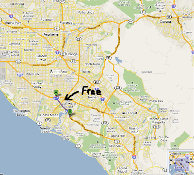
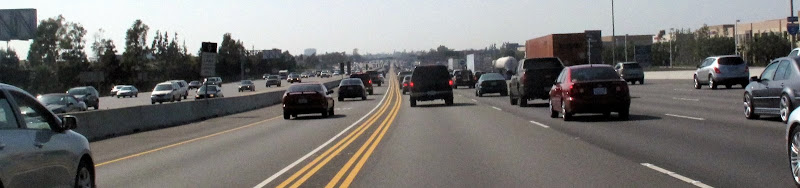
 If you have ever driven on the 405 through sections of Orange County, CA you may have noticed their is the 73 toll road that parralls the 405. When I first heard of this, I always routed my trips away from it, even with google maps telling me to drive on it. It wasn't for a few months of living in Orange County that I finally learned, through word of mouth, that a section of the 73 was free to travel on. That's right a toll road that was free!! However, there was a minor catch, if you missed the last free exit, you would have to pay to exit the toll road past that.
So where is this free section of the 73 toll road? Heres a picture and a Map.

So although this link is small compared to the length of the entire 73, it is quite a useful link! Just remember that when heading south the last free exit is BISON AVE. There is a large sign that will let you know, but the exit is a small one lane exit, so be sure to be careful not to miss it.
When heading North on the 73, as long as you get on at Bison, or any street north of bison, your section on the 73 should be free. This free section of the 73 has come in handy for many UC Irvine students who commute to school from areas such as Costa Mesa and Newport Beach.
I am unsure why this link is provided for free to all commuters, but my guess is due to some deal with the city of Irvine or the University of California. As for the toll road making any money, here is a decent article.

Update: A section of the 73 was closed for the filming of Hangover 3!!

Read more...

About This Blog

This blog is to allow for case studys to begin studying traffic.

  © Free Blogger Templates Photoblog III by Ourblogtemplates.com 2008

Back to TOP